Each day, high above the clouds, dozens of sophisticated imaging satellites circle the earth. These high-tech machines are capable of capturing extraordinary conditions and events that are nearly impossible to document from the surface of the planet. These remarkable images will be on display in a new Smithsonian traveling exhibition.
“Earth from Space” will premiere at the National Air and Space Museum in Washington, D.C., on Nov. 11 and remain on view through Jan. 7, 2007. The exhibition will then continue its national tour through 2009.
Developed by the Center for Earth and Planetary Studies at the Smithsonian’s National Air and Space Museum, in collaboration with the Smithsonian Institution Traveling Exhibition Service (SITES), “Earth from Space” explains how satellite imagery is gathered and used to expand our understanding of life on Earth. The exhibition reveals the awesome beauty of the planet’s surface through the “eyes” of a space satellite.
Made up of 40 beautifully detailed images of the planet, the exhibition features satellite photographs as diverse as the swirling arms of a massive hurricane and the grid-like pattern of Kansas farmland, to the triangular shadows cast by the Great Pyramids and the sinuous channels entering the Arctic Ocean. It also explores the remote sensing technology used to gather the images and discusses the individual satellites whose images are on display.
The exhibition is highlighted by a Magic Planet digital video globe—a digital display with a sphere-shaped screen. This tool will allow visitors to observe the global extent of images returned from orbiting satellites.
An educational companion Web site—www.earthfromspace.si.edu—will launch in October 2006. This interactive resource will contain an online version of the exhibition as well as additional images and information. It will also provide numerous educational resources, including lesson plans, classroom activities, Web site links and available publications.
The exhibition is curated by Andrew Johnston, a geographer at the National Air and Space Museum’s Center for Earth and Planetary Studies and author of “Earth from Space” (Firefly Books, 2004).
It has been made possible by Global Imagination. Additional support has been provided by the U.S. Geological Survey and the Smithsonian Women's Committee.
The Smithsonian’s National Air and Space Museum maintains the largest collection of historic aircraft and spacecraft in the world, is a vital center for research into the history, science and technology of aviation and space flight, and commemorates the development of aviation and spaceflight. The Center for Earth and Planetary Studies, a scientific research unit within the museum, performs original research and outreach activities on topics covering planetary science, terrestrial geophysics and the remote sensing of environmental change.
SITES has been sharing the wealth of Smithsonian collections and research programs with millions of people outside Washington, D.C., for more than 50 years. SITES connects Americans to their shared cultural heritage through a wide range of exhibitions about art, science and history, which are shown wherever people live, work and play. Exhibition descriptions and tour schedules are available at www.sites.si.edu.
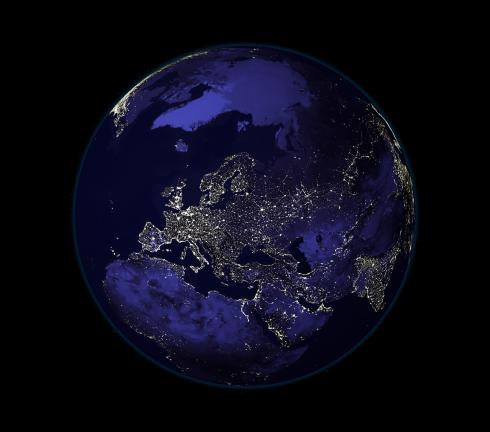
Streetlights are the source of most of the light seen in this image, but petroleum fires also contribute. A dark blue layer was added to the image to show where land masses are located. European cities are especially bright, and in Egypt, lights glitter along the Nile.
DMSP satellites, Data collected 1994-95
A 2002 QuickBird satellite image of Washington, D.C., shows the National Mall in the center.