
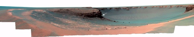
Victoria crater, located in Meridiani Planum, is ~750 m in diameter and ~ 75 m deep. This impact structure retains a ~5 m raised rim consisting of 1-2 m of uplifted rocks overlain by ~ 3 m ejecta at the rim crest and is shown in Figure 11. T. The main objective of our study was to determine the extent of Victoria crater's degradation to resolve its original, pristine crater morphology and the processes responsible for its modification.
Evaluating the degradation state of Victoria involved combining in situ observations by the Opportunity rover (Figure 2) with measurements from a digital elevation model (DEM) created from the High Resolution Imaging Science Experiment (HiRISE) stereo images1. Morphological evidence of crater modification by aeolian processes with possible contributions from mass wasting or fluvial activity are observed. The crater's current depth (d) to diameter (D) ratio (d/D), and rim properties indicate the crater is a significantly degraded primary crater rather than a pristine primary crater or a secondary crater1. If Victoria's original diameter was the observed 750 m, suggesting the crater retained its pristine form, a depth of 150 m and a d/D ratio of 0.2 would be expected, which is not consistent with the observed 75 m depth and d/D ratio 0.1. Additionally, the predicted height and width of the pristine rim as well as the ejecta to uplifted rock breakdown of the crater rim would be different from the observed values. Thus, we concluded Victoria crater represents a degraded form of an originally smaller and/or deeper primary impact crater1.
Constraining the crater's original depth and diameter involved comparing the expected characteristics of pristine craters 500-750 m across with the observed characteristics. Expected measurements for an original pristine crater 750 m in diameter, culminated in values larger than those expected. Meanwhile, expected measurements for a pristine crater diameter of 500 yielded smaller values than those expected. Calculations revealed the original pristine crater was close to 600 m in diameter, implying the crater had since been both widened ~150 m and infilled with ~50 m of sediments1.
This detailed study of Victoria crater using HiRISE images from orbit in concert with data on the ground from the Opportunity rover allowed for an unprecedented investigation of crater degradation on Mars.
1. Grant, J. A., S. A. Wilson, B. A. Cohen, M. P. Golombek, P. E. Geissler, R. J. Sullivan, R. L. Kirk, and T. J. Parker (2008), Degradation of Victoria crater, Mars, J. Geophys. Res., 113, E11010, doi:10.1029/2008JE003155.