A New Moon Rises
A New Moon Rises
This exhibition is now closed.
The Lunar Reconnaissance Orbiter Camera (LROC) has captured dramatic landscapes of the Moon since it was first launched in 2009. A New Moon Rises showcased those breathtaking images from Apollo landing sites to majestic mountains that rise out of the darkness of the lunar poles. The 61 large prints presented in this exhibition reveal a celestial neighbor that is surprisingly dynamic, full of grandeur and wonder.
This exhibition was made possible by the generous support of NASA and Arizona State University.
Explore Photography from the Exhibit
Global Views Exploration Sites Discoveries Vistas Topography Craters More Resources
About the Lunar Reconnaissance Orbiter Camera
The Lunar Reconnaissance Orbiter spacecraft has been studying the Moon from lunar orbit since 2009. Its high-resolution imaging system, the Lunar Reconnaissance Orbiter Camera (LROC), has taken over a million images of the surface and revealed details never before seen. These images are providing answers to long-held questions, and raising new questions about the Moon's ancient and recent past.
The mission was originally conceived to make measurements necessary to support future human missions to the Moon. After its first 15 months of operations, it began a mission of pure scientific exploration.
The lunar landscapes presented here are a small but magnificent sample of LROC images. They provide a glimpse of recent discoveries and reveal our nearest and most familiar celestial neighbor to be strikingly beautiful, still full of mystery, and truly amazing.

A digram of the Lunar Reconnaissance Orbiter's science instruments.
Lunar Reconnaissance Orbiter Camera (LROC)
Provides global imaging of the lunar surface. Consists of a Wide Angle Camera (WAC) and two identical Narrow Angle Cameras (NAC).
Cosmic Ray Telescope for the Effects of Radiation (CRaTER)
Measures the lunar radiation environment.
Diviner Lunar Radiometer (DLRE)
Provides thermal mapping to determine lunar surface and subsurface temperatures.
Lyman Alpha Mapping Project (LAMP)
Maps the lunar surface in the far ultraviolet in search of water ice.
Lunar Exploration Neutron Detector (LEND)
Maps distribution of hydrogen in the lunar soil.
Lunar Orbiter Laser Altimeter (LOLA)
Maps the topography and surface roughness of the Moon.
Mini-RF Synthetic Aperture Radar
Provides radar imaging of the lunar surface in search of water ice.
-
Custom Image Caption
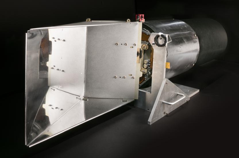
LROC Narrow Angle Camera (NAC)
This is a flight spare of the two NACs operating on the Lunar Reconnaissance Orbiter. At its heart is a powerful telescope with a 700-millimeter (28-inch) focal length. (The silver part is the telescope; the black part is a stray-light baffle). It allows the cameras to take black-and-white images with a resolution of a few meters or less. From an altitude of 50 kilometers (30 miles), a single NAC pixel covers an area on the surface only 50 centimeters (20 inches) square.Builder: Malin Space Science Systems, San Diego
Lent by NASA/GSFC/Arizona State University -
Custom Image Caption
LROC Wide Angle Camera (WAC)
The WAC obtains images of nearly the entire Moon in seven wavelengths and in stereo each month. The WAC displayed here was originally mounted on the Lunar Reconnaissance Orbiter before being replaced with a spare with a better color filter set. With the larger baffle, the WAC captures images in five visible light bands and two ultraviolet light bands. Visible-light image pixels cover 100 meters (330 feet). Ultraviolet image pixels cover 400 meters (1,300 feet).Builder: Malin Space Science Systems, San Diego
Lent by NASA/GSFC/Arizona State University -
Custom Image Caption
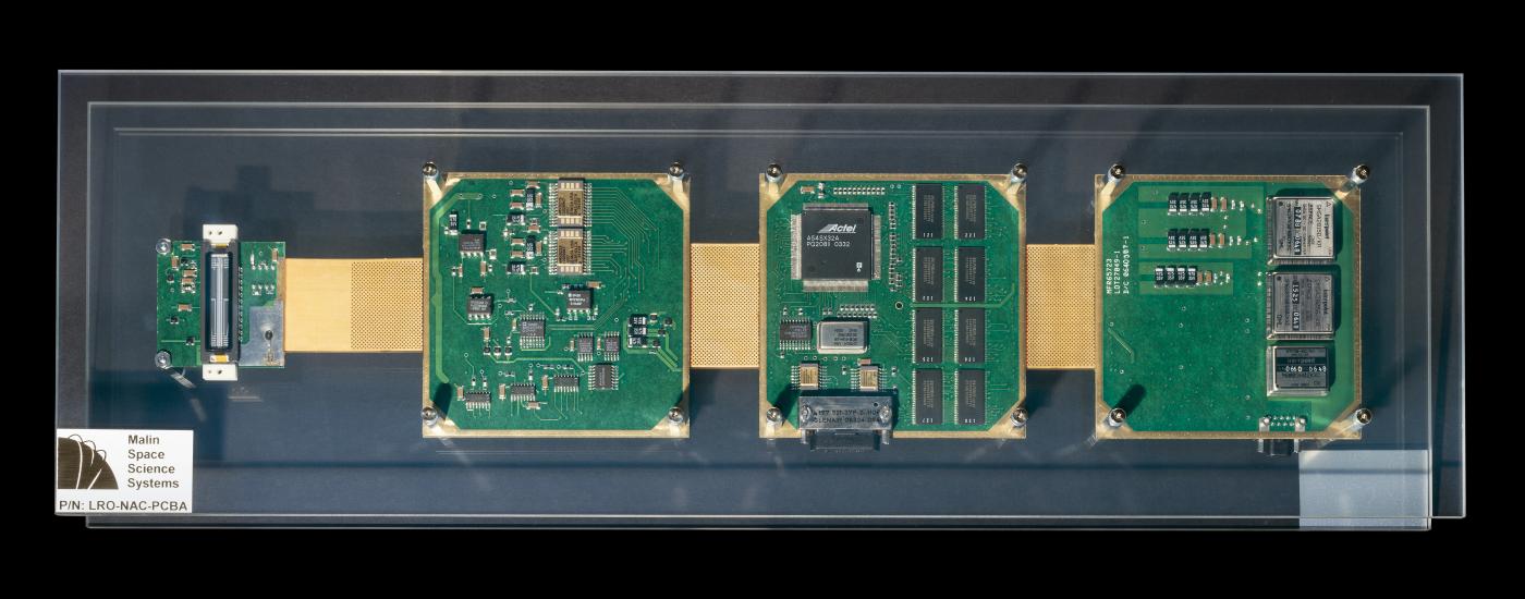
Narrow Angle Camera Electronics
The brains of all digital cameras are their electronics. The NAC electronics design is based on another planetary camera, the Context Camera on the Mars Reconnaissance Orbiter. The compact circuit boards on the NAC have been unfolded here for display.Lent by NASA/GSFC/Arizona State University


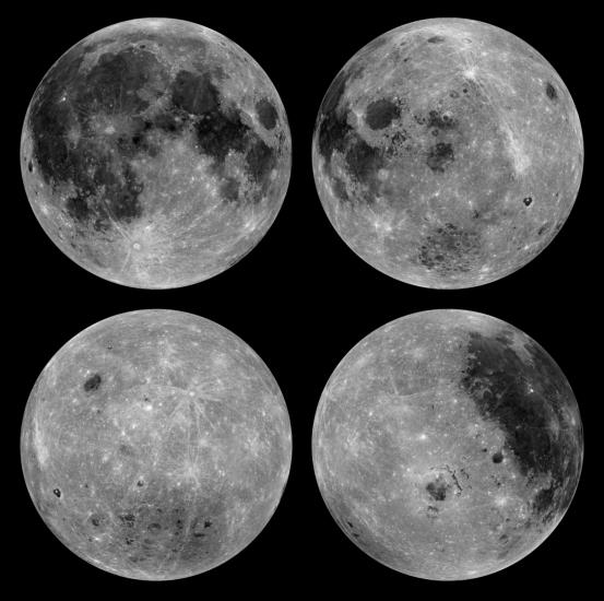
Global Views
From Earth we always see the same side of the Moon. In 1959 we got our first glimpse of the Moon's hidden face when the Soviet Luna 3 spacecraft returned the first image of the far side. The Lunar Reconnaissance Orbiter's polar orbit allows it to image the entire lunar surface in color and in stereo.
-
Custom Image Caption
Near Side Mosaic
For two weeks in 2010, the Lunar Reconnaissance Orbiter remained looking straight down while its Wide Angle Camera acquired about 1,300 images. The result was this spectacular mosaic. The low angle of the Sun during this period created crisp shadows that highlight the landforms.WAC Mosaic
-
Custom Image Caption
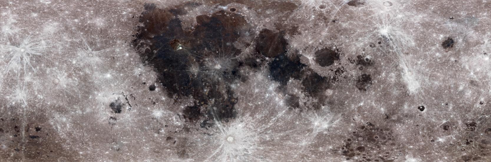
High Noon on the Moon
The sunlight at noon minimizes shadows but enhances subtle differences in surface brightness. The dark material is mare basalt, a volcanic rock that formed when lava erupted and flooded large impact basins early in the Moon's history. The brightest features are ejecta, deposits and bright rays of material thrown from relatively recent impact craters. Notice how dissimilar the near (upper left) and far (lower left) sides appear.WAC Mosaic
-
Custom Image Caption
The Moon's True Colors
The Moon may look black and white to the naked eye, but the Wide Angle Camera's filters show its true colors. The subtle variations in color seen here result from differences in the chemical composition of the rocks and soil of the bright highlands and the dark lowlands.WAC Mosaic
-
Custom Image Caption
The North and South Poles
At the Moon's poles, the Sun never rises high above the horizon. Long shadows make mapping these regions difficult. This polar mosaic of the Moon's north pole was created from images taken when the Sun was highest on the horizon and casting minimal shadows.WAC Mosaic
-
Custom Image Caption
The North and South Poles
At the Moon's poles, the Sun never rises high above the horizon. Long shadows make mapping these regions difficult. This polar mosaic of the Moon's south pole was created from images taken when the Sun was highest on the horizon and casting minimal shadows.WAC Mosaic
-
Custom Image Caption
Where the Sun Never Shines
Because the Moon's axis is tilted only slightly, the angle of the Sun's rays does not change much, so the Moon has no seasons. These maps of the north (this slide) and south (next slide) poles, where the sunlight angle is lowest, were created from thousands of images taken throughout a lunar year. They show what percent of a year each area of the map is sunlit. Low areas in permanent shadow appear black, while some peaks on nearby crater rims are sunlit most of the time. These areas of permanent shadow are very cold and may be where water ice has collected.Camera: NAC
-
Custom Image Caption
Where the Sun Never Shines
Because the Moon's axis is tilted only slightly, the angle of the Sun's rays does not change much, so the Moon has no seasons. These maps of the north (previous slide) and south (this slide) poles, where the sunlight angle is lowest, were created from thousands of images taken throughout a lunar year. They show what percent of a year each area of the map is sunlit. Low areas in permanent shadow appear black, while some peaks on nearby crater rims are sunlit most of the time. These areas of permanent shadow are very cold and may be where water ice has collected.Camera: NAC


Exploration Sites
The passion to explore our closest celestial neighbor has resulted in more than a dozen robotic landers from the United States, the former Soviet Union, and most recently China. One of the greatest achievements of the U.S. space program remains the six Apollo human landings on the Moon. The Lunar Reconnaissance Orbiter Camera has obtained detailed images of all these landing sites.
-
Custom Image Caption
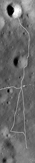
Apollo 11
Sea of Tranquility, July 20—21, 1969
"Houston, Tranquility Base here. The Eagle has landed." With those words, Neil Armstrong let the world know that the Apollo 11 lunar module had set down safely on the Moon. Although the Eagle was off course and heading for the rocky rim of West crater (the large crater in the photo), Armstrong intervened and guided the lander to a safer spot 500 meters (1,640 feet) farther west. Armstrong and Buzz Aldrin spent over two hours exploring the area.Image ID: M175124932R
Camera: NAC
Image width: 1,000 m (3,280 ft.) -
Custom Image Caption
Apollo 12 Landing Site
Oceanus Procellarum, November 19—20, 1969
Apollo 12's Intrepid made a pinpoint landing within walking distance of Surveyor 3, which had landed in 1967. Pete Conrad and Alan Bean collected parts from the robotic spacecraft for engineering assessment, as well as samples of ejecta from a relatively young impact crater and mare basalt rocks.Image ID: M175428601LR
Camera: NAC
Image width: 800 m (2,620 ft.) -
Custom Image Caption
Apollo 14 Landing Site
Fra Mauro Highlands, February 4—7, 1971
After the engineering triumphs of the first two landings, Apollo 14 was dedicated to scientific exploration. Alan Shepard and Ed Mitchell acquired samples from varying depths below the lunar surface by collecting material ejected from Cone crater (upper right). Samples from the edges of the ejecta are from near the surface, while samples from the rim are from deeper within the crater.Image ID: M175388134LR
Camera: NAC
Image width: 1.8 km (1.1 mi.) -
Custom Image Caption
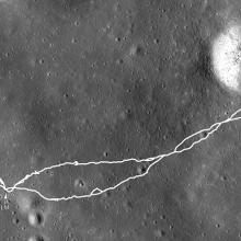
Apollo 15 Landing Site
Hadley Plains, July 30—August 2, 1971
The Apollo 15's Falcon landed 2 kilometers (1.2 miles) from Hadley Rille, a channel cut by flowing lava. Dave Scott and Jim Irwin became the first to explore a rille and the first to drive on the surface in a lunar roving vehicle. They spent almost three days exploring the Hadley-Apennine Valley and traveled over 28 kilometers (17 miles) in their rover. Among the many samples collected was a piece of the most ancient lunar crust, known as the "Genesis Rock."Image ID: M175252641LR
Camera: NAC
Image width: 4.55 km (2.83 mi.) -
Custom Image Caption
Apollo 16 Landing Site
Descartes Highlands, April 21—24, 1972
John Young and Charlie Duke undertook the first and only exploration of a purely highlands site. Their goal was to sample the light plains deposits thought to be remnants of a volcanic eruption. The light plains turned out to be material from the ancient Imbrium Basin that flowed hundreds of kilometers. Their explorations covered more than 26 kilometers (16 miles).Image ID: M175179080LR
Camera: NAC
Image width: 2.25 km (1.4 mi.) -
Custom Image Caption
Apollo 17 Landing Site
Taurus-Littrow Valley, December 11—14, 1972
A key science goal of what turned out to be the last Apollo lunar landing was to collect rocks to help date the formation of the Serenitatis Basin. Jack Schmitt and Gene Cernan explored that region on foot and in their lunar rover. With the help of LROC images, it appears that samples collected from the Sculptured Hills and North and South Massifs are actually ejecta deposits from the Imbrium Basin. The engineering and science results from Apollo 17 were an amazing capstone to the Apollo program.Image IDs: M142061915LR, M142068699LR
Camera: NAC
Image width: 15 km (9.3 mi.) -
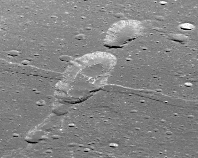
Custom Image Caption
A Valley Cut by a Scarp
Apollo 17 astronauts Jack Schmitt and Gene Cernan explored the Taurus-Littrow Valley (center right). One of largest lobate scarps (cliffs) on the Moon, named Lee-Lincoln, crosses the valley. The scarp appears as the sharp, narrow line across the valley floor between South Massif and North Massif mountains. The astronauts drove up onto this scarp to investigate the rocks of South Massif.Image ID: M1096343661LR
Camera: NAC
Image width: 40 km (25 mi.) -
Custom Image Caption
Luna 17 Landing Site
Mare Imbrium, November 17, 1970
The Soviet Luna 17 robotic spacecraft (left) gently settled to the lunar surface carrying the first successful robotic lunar rover, Lunokhod 1 (right). For the next 10 months, operators in the Soviet Union guided the rover across more than 10 kilometers (6 miles) of lunar terrain. Luna 17 returned video pictures of the surface and tested the properties of the lunar soil.Image ID: M114185541R
Camera: NAC
Image width: 150 m (492 ft.) -
Custom Image Caption
Chang'e 3 Landing Site
Mare Imbrium (Sea of Rains), December 14, 2013
China became the third nation to soft-land a robotic spacecraft on the Moon when Chang'e 3 landed just east of a small impact crater (right). The lander deployed a small rover named Yutu, or "Jade Rabbit" (left). It explored the immediate area for about two months, before a technical problem stopped Yutu in its tracks.Image IDs: M1142582775R, M1145007448LR
Camera: NAC
Image width: left, 1,200 m (3,937 ft.); right, 2,800 m (9,186 ft.)


Major Discoveries
Lunar Reconnaissance Orbiter images are reshaping our understanding of the Moon. We can now view the surface at amazing resolution and have a better understanding of how impact cratering, volcanism, and reshaping of the crust by tectonic (internal) forces reveal the Moon as a dynamic place. The "Dynamic Moon" could be the theme of future lunar exploration.
-
Custom Image Caption
Wrinkle Ridges Reveal Recent Activity
After the mare basins were flooded with basalt lava, they contracted. As they contracted, the basalt broke and folded, forming wrinkle ridges. Scientists believe that the fields of boulders on the ridge slopes, possibly shaken loose by moonquakes, could be related to recent shrinking of the Moon. The Moon, it seems, is not "dead" but still geologically active.Image ID: M135507772R
Camera: NAC
Image width: 1.85 m (1.1 mi.) -
Custom Image Caption
Random Scarps Show the Moon Is Shrinking
The thousands of small cliff-like features discovered in LROC images throughout the lunar highlands provide evidence of a shrinking Moon. Planetary geologists call them lobate scarps. Here, one cuts across a large impact crater. Lobate scarps are faults formed when the lunar crust breaks as it shrinks and thrusts blocks of rock upward. The shrinking occurs as more of the Moon's interior slowly cools and thus takes up less space.Image ID: M156626383LR
Camera: NAC
Image width: 4.3 km (2.7 mi.) -
Custom Image Caption
Young Craters Cut by Even Younger Scarps
Small, sharp lobate scarps (winding cliff-like features) are among the youngest lunar landforms. Scientists know this because small features on the Moon don't survive billions of years of steady bombardment by meteors. Also, these scarps cut through existing craters that are also very young. The scarps are so young they may even still be actively forming on the Moon today.Image ID: M103460280LR
Camera: NAC
Image width: 4.8 km (3 mi.) -
Custom Image Caption
Lunar Stretch Marks
A series of small, narrow troughs (upper half)—so small they could only be found in high-resolution images—formed where the lunar crust is stretching. As it stretches, the crust breaks apart along faults, and sections drop down into narrow troughs called graben. Chains of circular pits, formed when the lunar soil drains into voids, are found within these troughs. Like many other fault features on the Moon, these graben are very young. They show that the shrinking Moon is not shrinking everywhere.Image ID: M104756463R
Camera: NAC
Image width: 4.8 km (3 mi.) -
Custom Image Caption
Recent Volcanic Activity
Scientists had thought that volcanic activity ended on the Moon over a billion years ago. However, they have discovered more than 60 small volcanic flows in LROC images that appear relatively young (10 to 100 million years old). The smooth blobs within this D-shaped volcanic crater bear few impact craters—evidence of their young age.Image ID: M1108203502LR
Camera: NAC
Image width: 5.2 km (3.2 mi.) -
Custom Image Caption
Young Lava Flows
Smooth volcanic flows cover the floor of this shallow depression. They came from the circular raised feature that may be a small volcano. Many of the smaller flows appear unconnected to the central volcano, so the lava must have emerged from multiple vents. Future volcanic eruptions might still be possible.Image ID: M1123370138R
Camera: NAC
Image width: 2.4 km (1.5 mi.) -
Custom Image Caption
Overlapping Features Tell a Story
Scientists can tell the relative ages of lunar features by how they overlap or crosscut. Here, a wide flat-bottomed trough, or graben, first opened (left to right), then large areas collapsed into pits (lower left to upper right), and finally lava erupted very recently within the pits. Lava moving beneath the surface may have caused these events.Image ID: M1108117962LR
Camera: NAC
Image width: 13 km (8 mi.) -
Custom Image Caption
Young Features Hint at Hidden Depths
Lava flows have spread across the floor of this large collapsed area. Their lack of impact craters and steep sides show that they erupted relatively recently. Discoveries such as these are causing scientists to rethink their ideas about the Moon's internal composition. Perhaps a large reservoir of radioactive elements is generating heat deep within the Moon and keeping it volcanically active.Image ID: M1142616950LR
Camera: NAC
Image width: 1.9 km (1.2 mi.) -
Custom Image Caption
A Lunar Cavern
Collapse pits, where the near-surface lunar crust has caved in, can provide a window into the shallow subsurface. They are somehow related to the volcanic plumbing system that lava moved through when it flooded the mare basins early in the Moon's history. Could they be openings into a system of hollow lava tubes? These images, taken at different times, reveal that a cave extends at least 25 meters (82 feet) under the surface here. Arrows connect the same features.Image IDs: M126710873R, M155016845R, M152662021R
Camera: NAC
Image width: 200 m (660 ft.) -
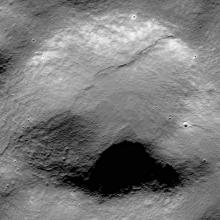
Custom Image Caption
A Natural Bridge on the Moon
The most extraordinary collapse pit found in LROC images is this one in King crater. What appears to be two closely spaced pits is actually one spanned by a natural bridge. It formed when a resistant or stronger portion of the roof remained when both sides caved in. The enlargement (right) shows light that passed under the bridge shining on the pit floor to the left of the bridge.Image ID: M113168034R
Camera: NAC
Image width: 500 m (1,640 ft.) -
Custom Image Caption
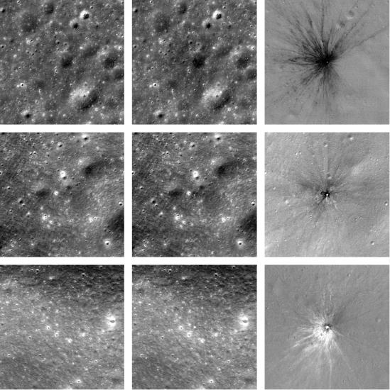
Fresh Impact Craters
Scientists can identify newly formed craters by comparing images of the same area taken over time. Using LROC images, they have found more than 200 new craters ranging from 1.5 to 43 meters (5 to 141 feet) across. The images here show three sets of examples. The images to the left were taken before an impact. The middle images were taken after an impact. The right images (called ratio images) combine aspects of the before and after images to highlight changes caused by the impacts.Image IDs: M1105837846LR, M1121160416LR, M1104273380LR, M1180855200LR, M1101866147LR, M1132496422LR
Camera: NAC


Lunar Vistas
Impacts, volcanic activity, and tectonic reshaping of the surface by internal forces have created a remarkably diverse lunar landscape. Despite its small size, the Moon has dramatic terrains that rival those of any object in the solar system. Some landforms are similar to those found on the Earth; others are quite different.
-
Custom Image Caption
An Irregular Impact Crater
Impact craters usually vary from circular to elliptical. Ryder crater's complicated "snowman" shape probably results from a combination of factors. It formed on a steep ridge, which may have affected its shape. And perhaps it was created by an asteroid that split apart before impact.Image ID: M176670797LR
Camera: NAC
Image width: 22 km (14 mi.) -
Custom Image Caption
Mount Marilyn
Astronaut Jim Lovell named this triangular mountain after his wife during the Apollo 8 mission, when he and his crew became the first to orbit the Moon. It later served as a navigational landmark during the first Moon landing. When Apollo 11 astronauts Neil Armstrong and Buzz Aldrin spotted Mt. Marilyn from their lunar module window at a particular moment, they knew they were on course.Image ID: M1142226401LR
Camera: NAC
Image width: 50 km (31 mi.) -
Custom Image Caption
The Final Apollo Landing Site
The Taurus-Littrow Valley (center) was the site of the Apollo 17 landing. Astronauts Jack Schmitt and Gene Cernan explored the lava-filled valley and the South Massif and North Massif, the mountains that border it.Image ID: M192703697LR
Camera: NAC
Image width: 25 km (16 mi.) -
Custom Image Caption
A Beacon in the Polar Darkness
The Sun only grazes the horizon near the lunar poles. But because Malapert Mountain rises 7 kilometers (4.3 miles) above its surroundings, it enjoys prolonged periods of sunlight. Locations such as this may be ideal for future long-term missions due to their extended access to solar energy and steady temperatures.Image ID: M1166454457LR
Camera: NAC
Image width: 50 km (31 mi.) -
Custom Image Caption
Intersecting Wrinkles
Lava once flooded and filled the mare basins. After it hardened into basalt, tectonic forces broke and buckled the volcanic rock into complex patterns of wrinkle ridges that zigzag through the dark mare. Three wrinkle ridges and their underlying faults come together here in Mare Frigoris to form an unusual triple junction.Image ID: M1190989008LR
Camera: NAC
Image width: 40 km (25 mi.) -
Custom Image Caption
A Cracked Crater
A squiggly valley (called a sinuous rille) roughly parallels the far wall of Posidonius crater. It was formed by a massive outpouring of lava that flowed chaotically across the landscape. Cutting across the center of the crater is a different type of valley (a linear rille). It formed later, as the floor of the crater was uplifted and the hardened lava cracked and pulled apart, creating a narrow trough, or graben.Image ID: M1108017413LR
Camera: NAC
Image width: 80 km (50 mi.) -
Custom Image Caption
A Valley Within a Valley
This valley on the Aristarchus Plateau is the largest sinuous rille on the Moon. It is more than 150 kilometers (93 miles) long, 4 kilometers (2.5 miles) wide, and 500 meters (1,640 feet) deep. Sinuous rilles are channels carved by eruptions of very fluid lava. As the eruption that formed this large rille waned and the amount of lava decreased, the smaller channel within it formed.Image ID: M1139200485LR
Camera: NAC
Image width: 65 km (40 mi.) -
Custom Image Caption
A Huge Volcanic Eruption
This giant pit, 20 kilometers (12.4 miles) wide and 2 kilometers (1.2 miles) deep, was formed by a massive, explosive volcanic eruption. The ash deposits blown from the crater may be rich in hydrogen, helium, iron, and titanium. They not only provide a glimpse into the composition of the lunar interior, but also could serve as resources for future lunar explorers.Image ID: M1160789857LR
Camera: NAC
Image width: 35 km (22 mi.) -
Custom Image Caption
Lunar Swirls
Lunar swirls are among the Moon's most beautiful and bizarre features. These bright, sinuous patterns look like they are painted across the flat mare terrain and up and over the tall peaks. Some scientists believe they may result from local magnetic field anomalies that shield the surface from the solar wind striking the lunar soil.Image ID: M191830503LR
Camera: NAC
Image width: 50 km (31 mi.) -
Custom Image Caption
The Strangest of Swirls
Reiner Gamma is one of the Moon's most distinctive and mysterious features. This striking, tadpole-shaped swirl puzzles lunar scientists. Some think that its origin, as with other swirls, is somehow related to the shielding effects of localized magnetic field anomalies.Image ID: M1127569280LR
Camera: NAC
Image width: 50 km (31 mi.) -
Custom Image Caption
A Slash Across Mountains
A band of rugged mountains form a rough central peak ring in Schrödinger Basin. This basin has only a fairly thin veneer of lava covering its floor, so its original form is mostly intact. Large parts of the basin were uplifted and pulled apart, causing the 100-kilometer (62-mile) long, 200-meter (660-foot) deep narrow trough, or graben, that cuts across the scene.Image ID: M1192453566LR
Camera: NAC
Image width: 65 km (40 mi.) -
Custom Image Caption
Rising from the Darkness
The regions around the lunar poles spend much of the day in shadow. Some areas are eternally dark. Here, the mountainous central peaks of Plaskett crater rise dramatically more than 2 kilometers (1.2 miles) above the shadowed crater floor.Image ID: M1181012362LR
Camera: NAC
Image width: 35 km (22 mi.)


Lunar Topography
To understand the Moon's geology, lunar scientists study its topography. How deep are its craters? How high are its mountains? How steep are its slopes?
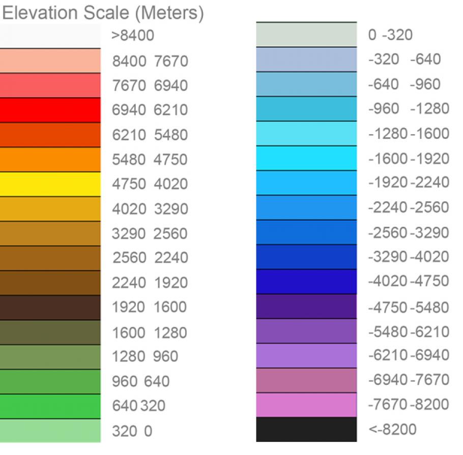
A graphic showing the elevation scale for topographic maps created by the Lunar Reconnaissance Orbiter Camera (LROC).
Scientists learn much of this from stereo imaging, which provides depth by comparing images of the same area taken from slightly different viewpoints.
LROC's Wide Angle Camera acquires stereo images across the entire lunar globe. Regions in permanent shadow are measured by the spacecraft's Lunar Orbiter Laser Altimeter. LROC's Narrow Angle Camera acquires very high resolution stereo by imaging the same area on successive orbits.
-
Custom Image Caption
North Pole Topography
In this view, the North Pole is at the center. The far side of the Moon is toward the top and the near side toward the bottom. The colors represent different elevations. The difference between near side and far side is striking. Highlands (orange and red) dominate the far side. The lower-lying mare basins (large darker blue areas) dominate the near side. -
Custom Image Caption
South Pole Topography
In this view, the South Pole is at the center. The far side of the Moon is toward the bottom and the near side toward the top. The large, roughly circular, low-lying area (deep blue and purple) is the South Pole—Aitken Basin, the largest and deepest impact feature on the Moon. -
Custom Image Caption
Lunar Topographic Map
This remarkable map, created using WAC images and LOLA laser profiles, shows the highs and lows over nearly the entire Moon at a pixel scale of 300 meters (980 feet). The colors represent elevation, from lowest (purple to black) to highest (red to white). The map is centered on the Moon's near side. -
Custom Image Caption
Topography of Orientale Basin
LROC's Wide Angle Camera makes stereo observations by imaging the same area during at least two orbits. The apparent difference in positions of features when viewed along different lines of sight is measured and converted into elevation data. This topographic map is centered on Orientale, the youngest of the large lunar impact basins. -
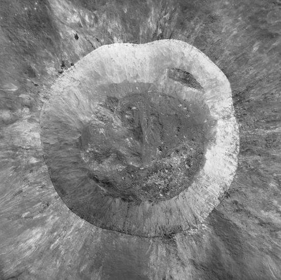
Custom Image Caption
Elevation Map of Giordano Bruno
Topographic contours derived from a digital terrain model of Giordano Bruno are overlain here on an image of the crater. The elevation difference between contour lines is 25 meters (82 feet). The steepness of the crater rim is indicated by the close spacing of the lines. The difference between the crater rim and floor is 3 kilometers (1.9 miles).Camera: NAC
Image width: 24 km (15 mi.) -
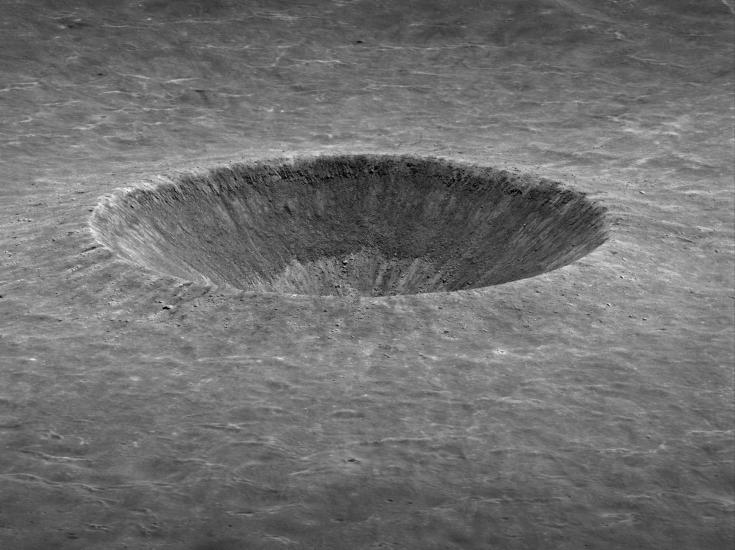
Custom Image Caption
3D Perspective View of Linné Crater
Stereo images are used to create a high-resolution topographic model of Linné crater, a young, bowl-shaped impact crater. That model enables scientists to view the crater from any angle—a powerful tool for interpreting an area's geology and planning future exploration.Camera: NAC
Image width: 3.5 km (2.2 mi.) -
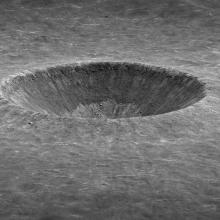
Custom Image Caption
Elevation Map of Linné Crater
Topographic contours derived from a digital terrain model are overlain here on an image of a section of Linné crater. The elevation difference between contour lines is 10 meters (33 feet). The closer the lines are, the steeper the terrain. The difference between the crater rim and floor is more than 500 meters (1,640 feet).Camera: NAC
Image width: 3.5 km (2.2 mi.)


Craters
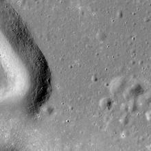
Giordano Bruno
Giordano Bruno may be the most spectacular of the young, large impact craters on the Moon. Rock melted by the impact pooled within the sharp-featured crater. Heaps of jagged boulders litter the floor, which itself has few craters—evidence that Giordano Bruno is very young. It may have even formed within the last few thousand years. If it was that recent, any humans watching at the time would have seen a startling flash on the Moon's edge.
-
Custom Image Caption
Directly Above Giordano Bruno
The crater is about 21 kilometers (13 miles) across. Rock melted by the impact collected in pools on the crater floor as much as 3 kilometers (2 miles) below the rim of its steep walls. In some places on the crater floor (middle) you can see where molten rock overtopped some features and flowed downhill before solidifying.Image: 25 NAC image pairs
Camera: NAC
Image width: 30 km (19 mi.) -
Custom Image Caption
Giordano Bruno from an Angle
In this striking view, the height and sharpness of the rim are evident, as well as the crater floor's rolling hills and rugged nature. At the bottom of the back wall is an intriguing whorl in the smooth, dark rock. Debris slid into the molten rock and caused the viscous puddle to flow in a circular motion before it froze solid.Image ID: M1138162093LR
Camera: NAC
Image width: 30 km (19 mi.) -
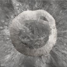
Custom Image Caption
Giordano Bruno Crater
Scale: 1:24,000
This relief model of the crater was derived from 80 LROC Narrow Angle Camera images taken from different angles, so scientists could accurately determine the height and proportion of the crater features. The topographic model's small pixel scale (about 5 meters or 16 feet) captures even subtle features of the crater. The model was carved from a single large block of material and airbrushed to accurately depict the brightness of features.Model courtesy of NASA/GSFC/Arizona State University/Pflug GmbH


Tycho and the Copernican Craters
Impact craters are incredibly diverse landforms. They vary greatly in shape, size, and complexity. Among the countless thousands of craters on the Moon, Tycho and other young "Copernican craters"—craters less than one billion years old—stand out for their sheer grandeur.
-
Custom Image Caption
Tycho Crater
Tycho is one of the best preserved near side impact craters. Its strikingly bright rays of ejected material radiate outward for great distances. They can be seen with even a small telescope.This oblique view highlights Tycho's young, sharp rim. The enormous heat of impact caused molten rock to flood the crater floor. The large terraces on the walls formed when large blocks of crustal rock slid down into the crater. They caused tsunamis of molten rock that left "high-water" marks toward the lower left of the central peak.
Image ID: M181286769LR
Camera: NAC
Image width: 105 km (65 mi.) -
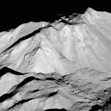
Custom Image Caption
Tycho's Central Peak
An isolated mountain rises 2 kilometers (1.2 miles) at the center of the crater. It was thrust upward through a pool of impact melt when the crustal rock rebounded very quickly after the impact. A covering of that now-solid impact melt coats the summit. It appears darker than material farther downslope on the peak and has a sharp, brittle edge.Image ID: M181286769LR
Camera: NAC
Image width: 16 km (10 mi.) -
Custom Image Caption
Close-Up of the Central Peak
The view shows the steep slopes and rugged top of Tycho's central peak. One astonishing detail is the large boulder—100 by 120 meters (330 by 400 feet)—perched near the top and resting on the impact melt that coats the summit. How did it get there? Perhaps it was ejected straight up and then landed just after the peak formed.Image ID: M162350671LR
Camera: NAC
Image width: 3 km (1.9 mi.) -
Custom Image Caption
Tycho Falls
Impact melt flooded down the flank of Tycho crater here, filled a depression, and then overflowed down a steep cliff before finally collecting in another depression far below. A vast amount of molten rock created by the heat of impact splashed over the crater rim and flowed tens of kilometers before creating this "frozen falls" of impact melt.Image ID: M1103603575LR
Camera: NAC
Image width: 10 km (6 mi.) -
Custom Image Caption
Mountains on the Moon
The enormous energy involved in making large craters creates rugged mountainous terrain in their centers and along their rims. Some of the mountains shown here are central peaks created when the floor of a crater rebounds upward from the force of impact. They are only found on the Moon in craters with diameters larger than about 15 kilometers (9 miles).Image IDs: M197959697LR, M196850878LR, M1105158497LR, M1137104619LR, M1136383661LR, M193025138LR, M198059280LR, M1124294869LR
Camera: NAC -
Custom Image Caption
Copernican Craters
These two impact craters have large, spectacular ejecta patterns of bright material thrown across the Moon's surface. These craters are no more than 1 billion years old—"Copernican age" in the lunar geologic timescale. Because they are so bright and have few impact craters on them, they may be as young as a few million years. Each is incredibly well preserved: crisp crater rims, steep crater walls, and delicate small-scale ejecta patterns. The overhead sunlight highlights the brightness variations.Image ID: M108992058LR
Camera: NAC
Image width: 3.2 km (2 mi.) -
Custom Image Caption
Copernican Craters
These two impact craters have large, spectacular ejecta patterns of bright material thrown across the Moon's surface. These craters are no more than 1 billion years old—"Copernican age" in the lunar geologic timescale. Because they are so bright and have few impact craters on them, they may be as young as a few million years. Each is incredibly well preserved: crisp crater rims, steep crater walls, and delicate small-scale ejecta patterns. The overhead sunlight highlights the brightness variations.Image ID: M154813223LR
Camera: NAC
Image width: 3.2 km (2 mi.) -
Custom Image Caption
A Very Young Crater
Spectacular ejecta surround this very young impact crater about 1,400 meters (4,600 feet) across. Since there are no superimposed impact craters on the ejecta, and the delicate lacy impact spray is still preserved near the rim, this crater formed very recently, perhaps sometime in the past few thousand years.Image ID: M1194434063LR
Camera: NAC
Image width 13.5 km -
Custom Image Caption
A Young Lunar Dimple
As this prominent lobate scarp (the winding cliff-like feature) formed, movement on the fault beneath caused uplift and deformed a Copernican crater into a dimple-like feature (top center). Boulders in the crater have aligned in rows parallel to the scarp. These features are very young in geologic terms—likely less than 100 million years old.Image ID: M190844037LR
Camera: NAC
Image width: 1.9 km (1.2 mi.)