“Great Valley” Found on Mercury
Media Inquiries
Public Inquiries
A new high-resolution topographic map of part of the southern hemisphere of Mercury has revealed a previously undetected large valley. This “Great Valley” may be the result of buckling of the Mercury’s outer silicate shell, its lithosphere, in response to global contraction. The findings were obtained using stereo images from NASA’s MErcury Surface, Space ENvironment, GEochemistry and Ranging (MESSENGER) spacecraft during the orbital phase of its mission and are reported in a paper published in Geophysical Research Letters by lead author senior scientist Thomas R. Watters of the Center for Earth and Planetary Studies at the Smithsonian’s National Air and Space Museum.
The paper, “Fault-Bound Valley Associated with the Rembrandt Basin on Mercury,” describes a broad valley about 400 kilometers wide with its floor as much as 3 kilometers below the surrounding terrain. The valley more than 1,000 kilometers long and extends into the Rembrandt basin, one of the largest and youngest impact basins on Mercury.
“Unlike Earth’s Great Rift Valley in East Africa, Mercury’s Great Valley is not caused by the pulling apart of lithospheric plates due to plate tectonics; it is the result of the global contraction of a shrinking one-plate planet,” Watters said.
The valley is bound by two large fault scarps. One of the bounding scarps is Enterprise Rupes, the largest fault scarp on Mercury. These large fault scarps were formed as Mercury’s interior cooled causing the planet to shrink and crustal rocks to be pushed together and thrust upward along faults making cliff-like landforms. But Mercury’s Great Valley is not just the result of the formation of two large, separated and parallel, fault scarps. The elevation of the floor of the valley is below the elevation of the terrain beyond the bounding, mountainous faults scarps. This suggests the valley floor was lowered by some mechanism that also formed the fault scarps.
The most likely explanation for Mercury’s Great Valley is long-wavelength buckling of the planet’s lithosphere in response to global contraction. Cooling of Mercury’s interior caused the planet’s single lithospheric plate to contract and bend. The bounding faults develop at the bends where contractional forces are the greatest and thrust crustal rocks upward while the emerging valley floor sags downward. The sagging valley floor lowered part of the rim of the Rembrandt basin.
“There are examples of lithospheric buckling on Earth involving both oceanic and continental plates, but this may be the first evidence of lithospheric buckling on Mercury,” Watters said. “Even though you might expect lithospheric buckling on a one-plate planet that is contracting, it is still a surprise when you find that it’s formed a great valley that includes the largest fault scarp and one largest impact basins on Mercury.”
MESSENGER was a NASA spacecraft launched Aug. 3, 2004, that began orbiting Mercury March 18, 2011, and was managed by the Johns Hopkins University Applied Physics Laboratory. Although it completed its primary science objectives by March 2012, the spacecraft’s mission was extended two times. The mission ended with a planned impact on the surface of Mercury April 30, 2015.
The National Air and Space Museum building on the National Mall in Washington, D.C., is located at Sixth Street and Independence Avenue S.W. The museum’s Steven F. Udvar-Hazy Center is located in Chantilly, Va., near Washington Dulles International Airport. Attendance at both buildings combined was 8.5 million in 2015, making it the most visited museum in America. The museum’s research, collections, exhibitions and programs focus on aeronautical history, space history and planetary studies. Both buildings are open from 10 a.m. until 5:30 p.m. every day (closed Dec. 25).
# # #
-
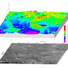
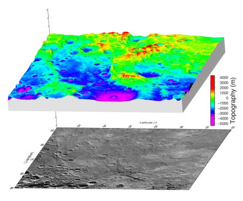
A high-resolution digital elevation model derived from stereo images obtained by NASA’s MESSENGER spacecraft has revealed Mercury’s great valley shown here in this 3D perspective view. Below the perspective view is a high-incidence angle image mosaic of the region. Mercury’s great valley is over 1,000 km long, extends into the Rembrandt basin, and is bound on one side by Enterprise Rupes, the largest fault scarp on Mercury. The vertical exaggeration, the difference between the vertical and horizontal scale, is 20×.
Credit: NASA/Johns Hopkins University Applied Physics Laboratory/Carnegie Institution of Washington/DLR
-
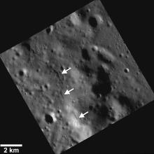
Mercury’s great valley revealed in a new high-resolution digital elevation model derived from stereo images obtained by NASA’s MESSENGER spacecraft. The great valley is shown by shades of dark blue in the colorized topography. The bounding fault scarps are more than 3 km above the valley floor in some areas. Part of the rim of the Rembrandt basin (white arrows), one of the largest and youngest impact basins on Mercury, was lowered when the valley formed.
Credit: NASA/Johns Hopkins University Applied Physics Laboratory/Carnegie Institution of Washington/DLR
-
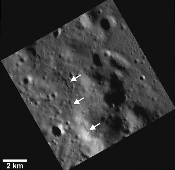
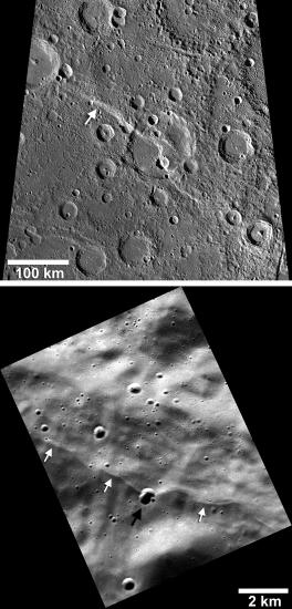
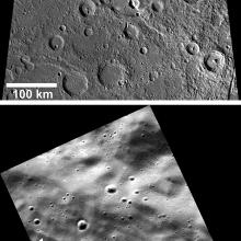
Two large lobate thrust fault scarps, cliff-like landforms formed when crustal materials are pushed together, break, and are thrust upwards, that bound Mercury’s great valley (white arrows) are shown in this high incidence angle image mosaic. The northern bounding scarp, named Enterprise Rupes, is the largest fault scarp on Mercury (upward pointing arrows), and Belgica Rupes is the southern bounding scarp (downward pointing arrows). The Enterprise Rupes fault cuts across the rim and floor of the Rembrandt basin (rightmost upward arrow), one of the youngest large impact basins on Mercury.
Credit: NASA/Johns Hopkins University Applied Physics Laboratory/Carnegie Institution of Washington/DLR