A graphic that reads "All year-end gifts matched until December 31 - up to $100,000!"
Reserve Free Passes
Membership

Search form

Visit

Visit

  • National Air and Space Museum in DC
  • Udvar-Hazy Center in VA
  • Plan a Field Trip
  • Plan a Group Visit
View of the Steven F. Udvar-Hazy Center tower at sunset

One museum, two locations

Visit us in Washington, DC and Chantilly, VA to explore hundreds of the world’s most significant objects in aviation and space history. Free timed-entry passes are required for the Museum in DC.

What's On

What's On

  • Events
  • Exhibitions
  • IMAX and Planetarium
Apollo 11: Buzz Aldrin on the Moon

At the museum and online

Discover our exhibitions and participate in programs both in person or virtually.

Explore

Explore

  • Stories
  • Topics
  • Collections
  • On Demand
  • For Researchers
space shuttle launch

Dive deep into air and space

Browse our collections, stories, research, and on demand content.

Learn

Learn

  • Programs
  • Learning Resources
  • Plan a Field Trip
  • Professional Development
Women in Aviation and Space Family Day

For teachers and parents

Bring the Air and Space Museum to your learners, wherever you are.

Give

Give

  • Donate
  • Become a Member
  • Wall of Honor
  • Ways to Give
  • Host an Event
Bob Hoover Gives an Air Show Performance

Be the spark

Your support will help fund exhibitions, educational programming, and preservation efforts.

Geography from Space Quiz 8

  1. Breadcrumb Home
  2. Learn
  3. Programs
  4. Geography From Space
  5. Geography From Space Quiz 8
Satellite image of a country that is bordered by Italy and Switzerland.

Question 1 Clue:

Italy and Switzerland are among the nations that border this country on the east. The Pyrenees Mountains border it on the south. Name the country (marked with arrows).

MODIS image, courtesy of Jacques Descloitres, MODIS Land Science Team, NASA.GSFC

France

Satellite image of the Zambezi River. An arrow points to a large waterfall.

Question 2 Clue:

The Zambezi River plummets about 130 meters (over 420 feet), forming a giant waterfall (arrow). Name the waterfall.

ISS image, courtesy NASA/JSC

Victoria Falls

Satellite image of a state in the United States where the Appalachian Mountains cut through the state's southeast edge.

Question 3 Clue:

The Appalachian Mountains cut across this U.S. state. A major city on the state’s southeast edge was once the nation's capital. Name the state.

Landsat images with National Elevation Dataset topography, courtesy of USGS

Pennsylvania 

Satellite image of a large island country. The left side of the country is largely arid.

Question 4 Clue:

This island nation is among the largest countries of the world. Over 2/3 of its terrain is arid or semi-arid. Its isolation has made it home to many distinctive species of animals and plants. Name the country.

SRTM image, courtesy NASA/JPL/NGA

Australia 

Satellite image of Senegal. An arrow points to the city of Dakar.

Question 5 Clue:

Dakar (arrow), the capital city of Senegal, lies on the end of a small peninsula that marks the westernmost point of a continent. Name the continent.

MODIS image, courtesy of Jacques Descloitres, MODIS Land Science Team, NASA/GSFC

Africa 

Satellite image of a group of islands. Florida is to the west of the islands and Cuba is to the South.

Question 6 Clue:

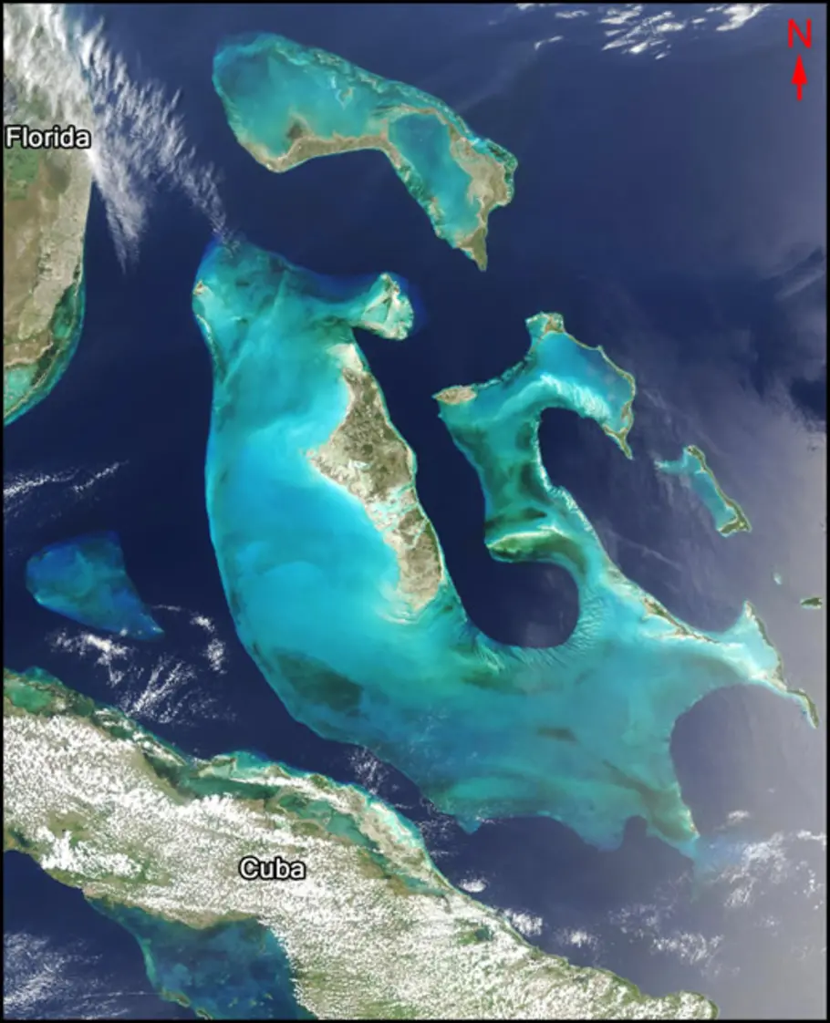
Clear light blue waters mark the shallows around this group of islands. Name the island group.

MODIS image, courtesy of Jacques Descloitres, MODIS Land Science Team, NASA/GSFC

Bahamas 

Satellite image of coastline of the Rio de la Plata. Towards the bottom of the image is the muddy Parana River. An arrow points to a city on the banks of the Parana River.

Question 7 Clue:

The mud-colored Paraná River carries sediments to the estuary known as the Río de la Plata. A capital city (gray area marked with an arrow) lies along the estuary's southwest edge. It is one of the largest cities in the Western Hemisphere. Name the city.

MODIS image, courtesy of Jacques Descloitres, MODIS Land Science Team, NASA/GSFC

Buenos Aires

Satellite image of a large crescent shaped island nation on the continent of Asia.

Question 8 Clue:

This Asian nation is made up of many islands, the largest of which is called Honshū. Name the country.

Aqua/MODIS image courtesy of Jeff Schmaltz, MODIS Rapid Response Team, NASA/GSFC

Japan

White arrows point to a country south of the Himalayas in a satellite image of both.

Question 9 Clue:

Arcing across this image are the snow-covered Himalayas. The second most populous country in the world lies to the south (arrows). Name the country.

Terra/MODIS imagery courtesy of NASA Earth Observatory

India

Satellite image of a state in the United States that is long and L shaped.

Question 10 Clue:

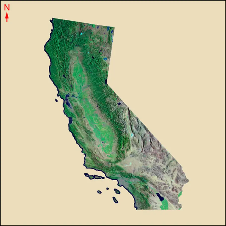
This U.S. state is the third largest by area. In the 19th century, it experienced a "Gold Rush" which brought dramatic change and significant growth. Name the state.

Landsat image with National Elevation Dataset topography, courtesy of USGS

California 

Satellite image of a group of northern islands in the Arctic Sea.

Question 11 Clue:

For centuries explorers have searched for a Northwest Passage, an arctic sea route that would connect two great oceans. In recent summers, enough long standing sea ice has melted away to temporarily open such a passage through a group of northern islands. Name the country that contains these islands and the Northwest Passage.

Aqua/MODIS image courtesy of Jesse Allen, MODIS Rapid Response Team, NASA/GSFC

Canada 

This quiz was adapted from quizzes published in 2009 and 2008.

Admission is always free.
Open daily 10:00 am – 5:30 pm

National Air and Space Museum

National Air and Space Museum 650 Jefferson Drive SW
Washington, DC

202-633-2214

Free Timed-Entry Passes Required

Steven F. Udvar-Hazy Center

Steven F. Udvar-Hazy Center 14390 Air and Space Museum Parkway
Chantilly, VA 20151

703-572-4118

  • About
  • Become a Member
  • Newsroom
  • Host an Event
  • Get Involved
  • Contact
  • Privacy
  • Terms of Use
  • Accessibility