

Observing our Planet
Throughout history, we have sought to better understand our world by viewing it from above.
We first climbed trees, hills, and fortress towers to observe the lay of the land. Aircraft and spacecraft look down on Earth to predict the weather, survey the terrain, monitor crops and forests, plan cities, locate resources, and gather intelligence.

Before the development of practical aircraft photography, aerial views of the Earth were obtained in many different ways. Our first looks at the Earth from above came from kites, rockets, balloons, and even pigeons.
From the first clumsy flights and fuzzy photos, airplane photography developed rapidly into a precise and useful tool for looking at Earth. Surveyors, mappers, geologists, resource managers, urban planners, and military strategists have all come to rely on the airplane to view of our world.

As you travel higher and higher into the sky, you will eventually reach what is called the von Kármán line at 100km (62 miles) above the surface of the Earth. The von Kármán line denotes the boundary between Earth's atmosphere and space. It does not mark any actual physical change, rather it is a regulatory boundary generally agreed upon by most aerospace governing bodies such as the Fédération Aéronautique Internationale (FAI).
From this vantage point, we can view huge areas at a glance, scan whole continents, and trace the courses of immense rivers and mountain ranges. Looking down from spacecraft or satellites in orbit around the Earth expands our narrow surface view and allows a better understanding of the vast world around us.
Observing our Planet from the Air

Aerial Photography
The Beginnings and Basics
Early airplane photography was not without its technical difficulties. In 1911, the enthusiastic flyer pictured here photographed his own feet!

Aerial Photography at Work
Pioneering Aerial Archeology by Charles and Anne Lindbergh
In 1929, Anne Morrow Lindbergh gazed out the window of a Sikorsky S-38 flying boat similar to this one, entranced by the view before her: gleaming stone structures only recently freed from the thick tropical vegetation of the Yucatan peninsula in Mexico, It was Chichén Itzá, a remnant of the Mayan civilization that thrived there between 750 and 1200 AD. The Lindberghs captured the first aerial photographs of the site, as well as other historical sites. Their milestone photography illuminated the details of pre-Columbian societies and became permanent aerial records of these settlements.
Aerial Photography and Military Reconnaissance

There are many different methods through which humans might spy on one another. But what if you could spy on your enemies from the sky? As the United States entered the aerial age in the early 20th century, such tactics became commonplace.

Aerial photography was combined with code-breaking, spying, French resistance reports, and other intelligence sources to enable the success of the bold and risky campaign known as D-Day.

On October 14, 1962, Maj. Richard Heyser Cuban airspace for about 6 minutes and took 928 pictures from his U-2 spy plane. What those photos revealed triggered a crisis that pushed the world to the brink of nuclear Armageddon.

The technologies used to carry out military reconnaissance are varied—from balloon reconnaissance, to modern unpiloted aircraft such as the Predator drone. Explore three technologies used for military reconnaissance: balloons, aircraft, and satellites.
Aerial Photography in the Museum's Collection
Observing our Planet from Space

Our Eyes in Space: Satellites and Astronauts
On the evening of April 1, 1960, President Dwight Eisenhower saw the first image sent back from space by the Television InfraRed Observation Satellite (TIROS) 1 weather satellite. As he considered the grainy black and white image of cloud cover over the eastern United States and Canada, he remarked “the Earth doesn’t look so big when you see that curvature.” As the 1960s unfolded, new images of Earth, especially those from astronauts during Mercury and Gemini spaceflights, moved to the center of public attention and the deepened questions of humanity’s relationship to their home planet. Today, these images provide scientists with crucial data for tracking weather patterns, climate change, and natural disasters like hurricanes or wildfires.

Predicting the Weather
Cloudy with a Chance of Orbital Observation
As you get ready to head out of your house, you may ask yourself a few questions to make sure you are fully prepared to take on the day: Do I have my keys and wallet? Is there a test in science class today or is that tomorrow? Did I pack all the materials I need for that important meeting at work today? And perhaps one of the most universal questions: What will the weather be like?
In modern society, we often take the ability to get a daily weather report at a moment's notice for granted. We flip on the news, we open the weather app on our smart phone, or we look up our regions weather on the internet. Have you ever thought about how meteorologists predict the region's forecast? For the answer, we need to look to none other than the sky.

Seeing Earth through Astronaut Eyes
Our Window to the World
The Apollo missions to the Moon gave people a completely new view of Earth and its moon. In the decades after the Apollo program ended, beginning with Skylab missions in the 1970s, then Space Shuttle missions, and now the International Space Station, an orbital location was provided for astronaut activities, including setting eyes on the wonders of our home planet.
How do we capture images of Earth all the way from Space?
Let's learn about a few of the instruments that are used in orbital photography.
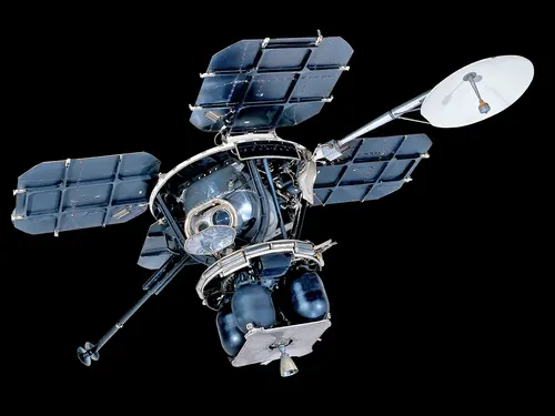
Terra Instruments: The Terra satellite, which was launched in 1999, carries five instruments that take measurements of Earth at the same time. Its five sensors (ASTER, CERES, MISR, MODIS, MOPITT) observe a wide range of things, including the clouds, oceans, ice and snow, as well as carbon monoxide in the atmosphere.
Terra itself is the size of a small school bus, and orbits the Earth 16 times a day. The satellite’s multiple instruments make observations simultaneously, which lets scientists compare different measurements, and study Earth over time.
Landsat 8: Landsat satellites have been monitoring the Earth since 1972. Tens of billions of square kilometers of the Earth are observable by Landsat sensors, and this imagery has provided invaluable information to scientists. The Landsat 8 satellite is the latest in the Landsat project and launched in 2013.
Suomi-NPP: The Suomi National Polar-orbiting Partnership satellite (named for groundbreaking satellite meteorologist Verner E. Suomi) launched in 2011. Its instruments collect data on weather and long-term climate change, building on data collected by NASA’s Earth Observing Systems satellites.
Earth Observing-1 (EO-1): Though EO-1 was initially a one-year mission to test satellite observation technology, the instrument collected data for 17 years before it was deactivated in the spring of 2017. While in orbit above Earth, EO-1 mapped lava flows, tracked the re-growth of forests in the Amazon, and captured images of New Orleans floodwaters after Hurricane Katrina.
International Space Station: Multiple instruments take images of Earth from aboard the ISS—there is even one that you can control from home! The Sally Ride EarthKAM lets students take photos of Earth from a digital camera mounted on the space station.
Orbital and Space Photography at Work
When you hear the term “space archaeology” you might envision a khaki-clad astronaut excavating the Moon. But space archaeologists are actually Earth-bound researchers who use satellite and other aerial imagery to assist in archaeological applications right here on our home planet.

Most people know that satellites in orbit do useful things such as collect images of the Earth's surface. Join former Museum scientist Andrew Johnston in exploring what is really visible in different types of satellite data.

Since the very first Earth Day in 1970, spaceflight and the environmental movement have been deeply entwined, which shapes how we think about Earth as home as well as our responsibilities to sustain that home.

By the late 1950s, the limitations of reconnaissance from aircraft and balloons as well as a failure of diplomacy created an opening for a new technology—spy satellites.
Orbital and Space Photography in the Museum's Collection

Quiz Yourself
More Resources about Reconnaissance
 Exhibition
 Exhibition
 Story
Story

 Story
Story

 Deep dive